|
|
Hurricane Rita Chase Account - September
21st - 24th, 2005 |
|
|
|
These few stock
images below are only a small sample. Hundreds of additional
stock photos |
|
available for
immediate licensing from Ultimate Chase Inc's sister site
www.ExtremeNature.com |
|
|
 |
|
|
|
Ultimate Chase
Documents Hurricane Rita in several locations including Lake
Charles, Westlake, Beaumont, Port Arthur, and The Florida Keys! |
|
|
|
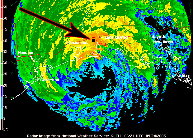
Radar Image showing Ultimate Chase's Location During
Hurricane Rita: |
| |
|
Ultimate
Chase was located at the Isle of Capri Casino
Parking Garage near Westlake, LA |
|
|
|
|
|
|
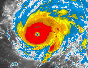
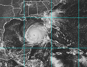
Hurricane Rita Satellite Images
Below: |
|
|
|
Hurricane Rita Photos and Video
Stills From Landfall #01 in the Florida Keys: |
|
|
|
Hurricane Rita Photos and Video
Stills From Landfall #02 in Texas and Louisiana: |
|
|
|
Hurricane Rita Chase Account
Below: |
|
|
|
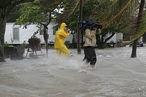
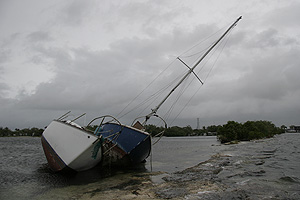
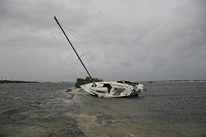
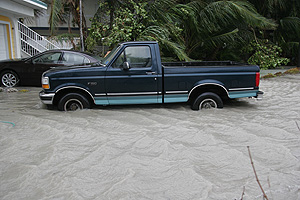
Landfall # 01:
Key West and
the Florida Keys..... |
|
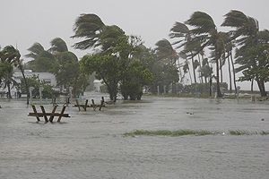
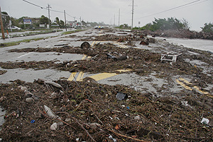
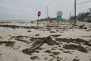
I documented
Hurricane Rita's storm surge effects in the lower Florida
Keys. Rita did not make a direct strike on the Keys, but
came close enough to cause significant storm surge and winds
up to 100mph. The surge came completely over US-1 in a few
locations and covered the road with sand, rocks, seaweed,
and other debris. The Keys suffered some damage, but overall
was very very lucky. If Hurricane Rita would have tracked
just 30 miles further to the north and started the rapid
intensification just 48 hours earlier, it could have nailed
the keys as a Cat-5 Hurricane. Hurricane Rita became a
dangerous Category 5 Hurricane with an astonishing
barometric pressure of 897mb just hours after passing the
Florida Keys. If the timing was a little different the
Florida Keys could have suffered Catastrophic damage !! |
|
|
|
Landfall # 02:
Lake
Charles, Beaumont, and Port Arthur, TX...... |
|
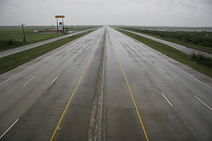
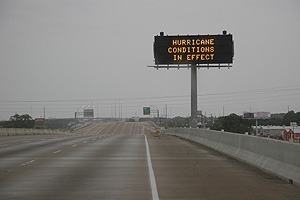
I flew
into DFW airport around 9:00pm only to find very
limited supplies. The gas was already scarce and
spare gas canisters were nowhere to be found. I
stocked up on enough food and water for 10 days and
headed down to the Gulf Coast. I was severely
crunched for time because I was scheduled to be on
NBC's Today Show with Matt Lauer at 5:45am and all
the main roads to the gulf coast were reversed to
have all north bound traffic. This meant I had to
take all back roads the entire way down to the coast
and this took FOREVER. On my drive down to the coast
I saw many vehicles pulled over on the side of the
road out of gas, overheated, and just simply broke
down. Many families were sleeping on the side of the
road in the grass because the traffic was so bad
that they were stuck. Most gas station were out of
gas, WHERE is the evacuation plan, WHAT is the
evacuation plan, DO we have an evacuation plan for
major cities. NO !! If a plan was in place the first
priority when evacuating thousands of people would
have been to keep the gas stations stocked with gas
! |
|
|
|
I arrive
at Galveston Island in time for the Today Show
interview and to start surveying the area for
locations to use to document Hurricane Rita. As the
day progresses my target area changes to further up
the coastline. I decided to team up with friend Brad
Riley in Beaumont, TX and use his hotel as the new
base location. We went down to Port Arthur to survey
the area and did not trust being there for a night
landfall. If the seawall was breached the water
would have poured in fast and instantly would have
become a very dangerous situation. I wasn't
convinced that Port Arthur was the best place to be
to get the max winds anyway. After analyzing the
data more, Brad and I decided to head east. We went
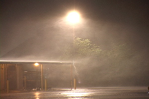
to an area called Westlake, LA. It was located just
west of Lake Charles and we found a parking garage
with plenty of lights on because of the backup
generator at the Isle of Capri Casino. The most
valuable item when documenting night land falling
Hurricanes is finding some kind of lighting. We shot
video for several hours in the eastern eyewall and
decided to document the eye of Hurricane Rita next
!! |
|
|
|
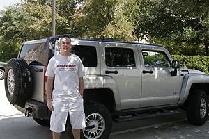
IN THE
EYE......Brad and I decided to document Hurricane
Rita's eye by heading west out of the eastern
eyewall into the eye. We were in a solid rugged
Hummer and felt comfortable driving in these
conditions because it was interstate roads the
entire way into the eye
(Interstate 10).
This eye experience is my top of all time. We
recorded a barometric pressure of 940mb
( My
Personal Lowest ).
My
previous record was 942mb in Hurricane Charley and
just when I thought that was going to be the
highlight of the eye experience, BAM !!! A bird
dives right into my windshield and it's wing gets
stuck under the windshield wiper and keeps moving
back and forth as the wipers wipe. It startled both
of us ! We didn't see it coming, the bird just dove
right out of the sky and straight down into the
windshield. During the next 20 minutes while driving
in the eye about 20 more birds repeated this
scenario and died. There were also allot of birds
that were already dead on the road and they were not
run over, they either dove into someone else's
windshield or just simply dropped out of the sky. I
am going with the latter part because there was no
one else on the roads during the eye experience. It
felt like we were in the Alfred Hitchcock movie "The
Birds". While driving in the eye we saw hundreds of
these exhausted birds that must have been trapped in
the eye for days and maybe even since Florida. Birds
get trapped in the center of a developing system and
literally get locked inside as the system develops
into a organized hurricane with a well defined eye.
The birds can't fly out because the eyewall
surrounding the eye has wind speeds that would kill
a bird instantly and the birds can't fly up and out
of the Hurricane, this would be too high for the
bird and the bird would die, So they are literally
trapped! These erratic birds seemed possessed ! |
|
|
|
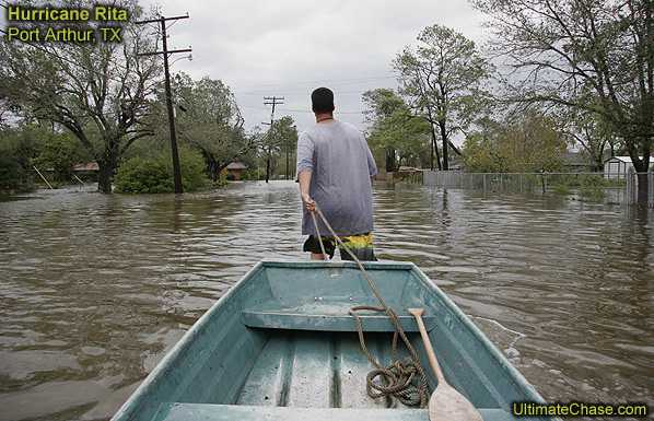
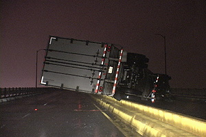
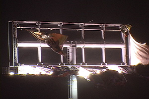
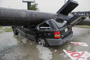
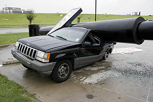
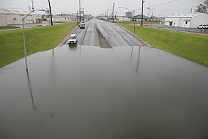
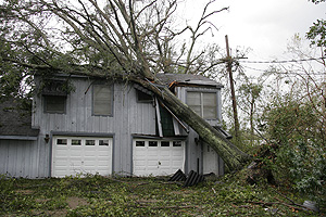
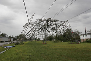
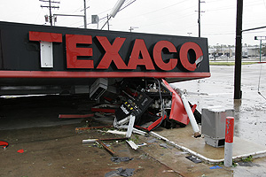
We
arrive back to the hotel in Beaumont at daybreak and
the wind is still blowing in the 60mph-70mph range,
but decided to get a few hours sleep at the hotel
before we go back out an document the damage. We
head back out around 12noon to find severe damage in
the area the eyewall passed through. We documented
the storm surge that came into Port Arthur by
catching a ride on a canoe with some of the locals.
The water wasn't super deep, but high enough to get
into peoples homes and cause lots of damage. After
many days of very little sleep we had become wore
out and decided to head back north. We soon got back
to areas with power and gas in Dallas and called it
a chase ! What a season. Hurricane number 4, with 2
of them making landfall twice, so really this was
Landfall Mission number 6 and already Hurricane Stan
is on the Horizon......... |
|
|
Photographer, |
|
|
 |
|
|
|
Website copyright notice below: |
|
Hurricane Rita video stills and photos are
copyrighted and protected under United States and International |
|
copyright laws. These video stills may not be
reproduced in any form, downloaded, stored, or
manipulated |
|
without prior permission from © Ultimate Chase, Inc. |
|
|
|
 |
|
|
|
|